Showing posts with label Barberton_Supergroup_Geo. Show all posts

Thursday, November 10, 2016

11th CGS Field School - Barberton

Firstly, I must apologise for the delayed update. For the last few days our group has been living on the banks of the Komati river deep within the southern Barberton mountains. This isolated region is definitely an ideal location for investigating the Barberton greenstone belt and discussing many important aspects of the early Earth, however is too deep for any mobile reception.

Anyway, I am happy to report that the team did have three (and today being the forth) excellent days exploring the Barberton greenstone belt and have clearly gained much from this experience.

The proper Barberton Mountainland welcome


Day one

The first day was spent along the Komati River with a section across the topmost units of the Onverwacht Group. The group had an opportunity of closely examining the contact relationships between the Mendon, Kromberg and Hooggenoeg Formations/Complexes. The contact between these units are clearly defined by the occurence of thick chert layers. The Buck Reef Chert, which separates the Kromberg and Hooggenoeg also has apparent algal biomats and early signs of life. During this time, we also began the complex debate regarding the dynamic functionality of the early Earth.

TL: Alteration of Hooggenoeg ultramafic rocks; TR: Plagioclase-varioles in Hooggenoeg pillow basalt; BL: The H6 conglomerate near the top of the Hooggenoeg Formation; BR: Magmatic breccia contact between the 3450 Ma Theespruit Pluton and the c. 3.5 Ga Sandspruit ultramafics


This debate was exasperated when the group came across the H6 within the Hooggenoeg, which includes sandstone and conglomerates. This apparent volcano-sedimentary sequence is surrounded by mafic and felsic interlayered volcanics and suggests the presence of kind of fluvial environment and potentially detrital input associated to tectonic-related mountain building processes.

The team examining highly altered ultramafic rocks in the Komati river


Sheep bridge across the Komati River, built in c. 1890


Pillow basalts in the Hooggenoeg Formation/Complex


Day two

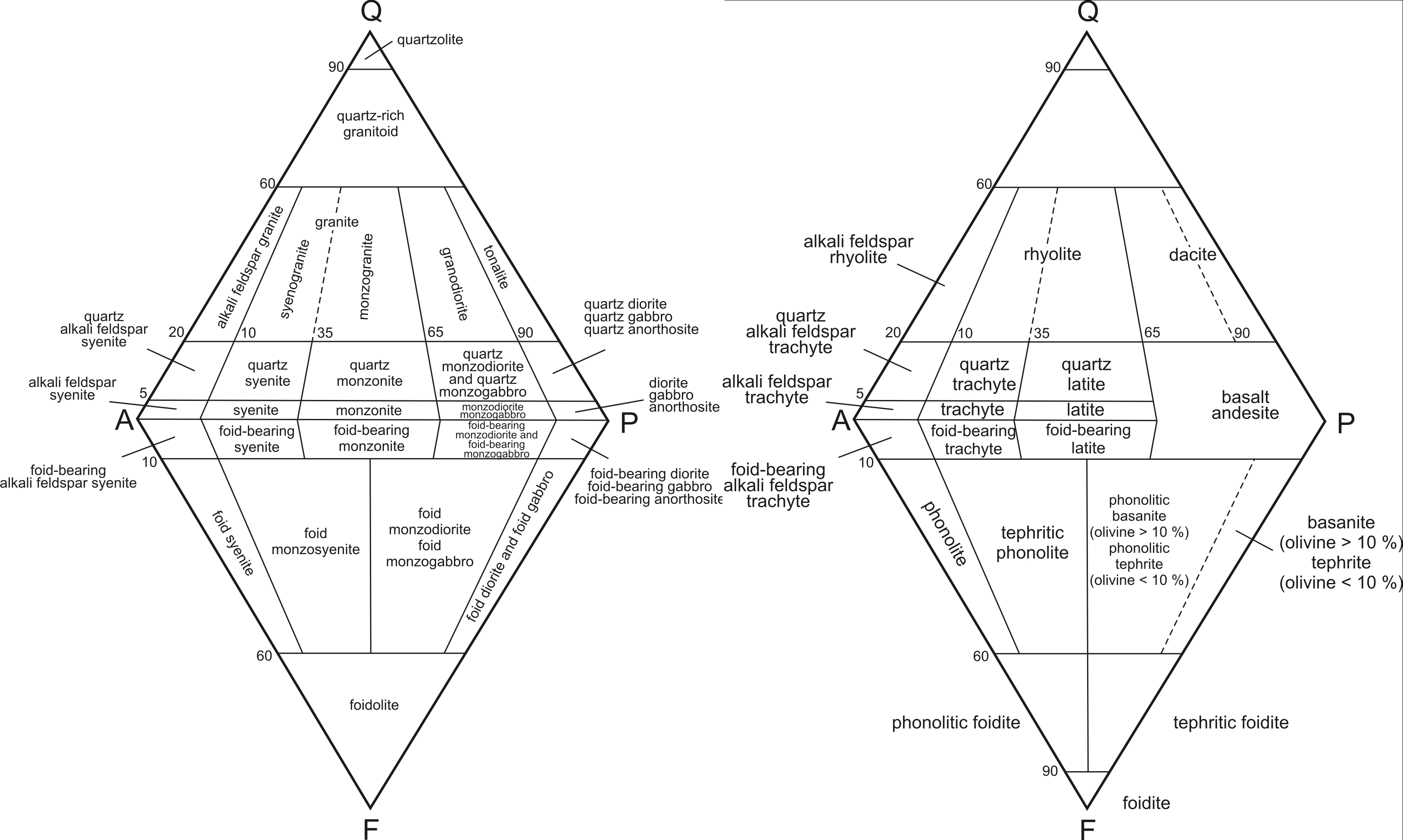
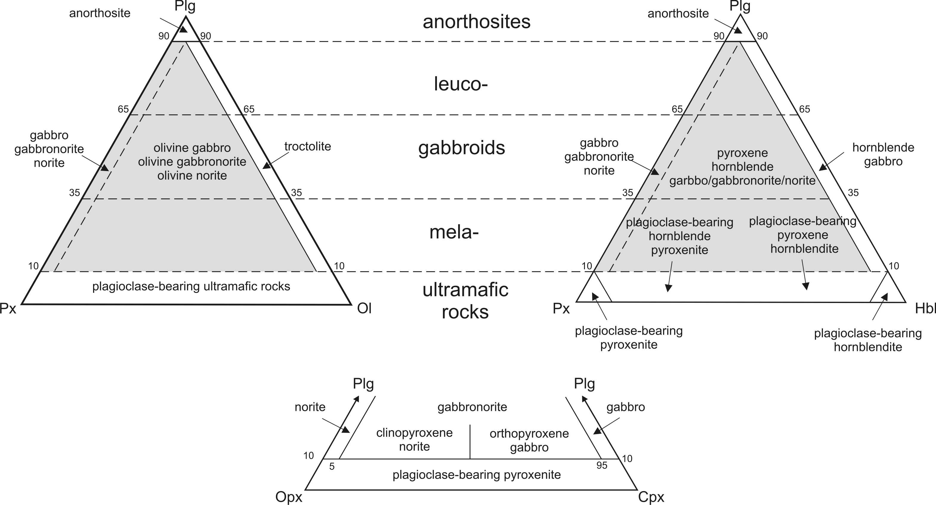
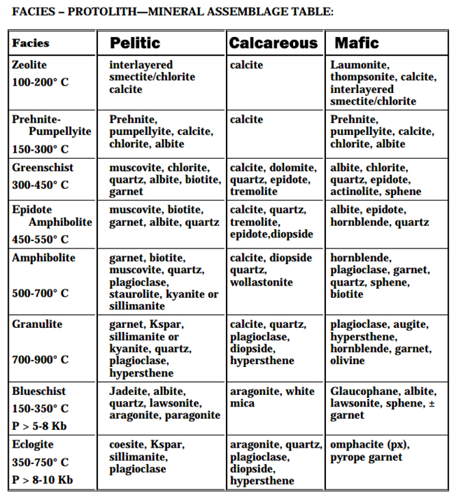
During the second day, the group completed the Onverwacht Group, visiting the lowermost units. This included the Sand/Theespruit and Komati Formations. Of particular interest was the magmatic breccia contact between the c. 3510 Ma Theespruit Ultramafic rocks and the 3450 Ma Theespruit pluton. Here, the ultramafic rocks are also metamorphosed to upper amphibolite facies, quite a substantial PT increase from the overall greenschist grade. Having not completed a Thermocalc course, we briefly discussed the metamorphic implications of this and closely examined the occurence of garnet in the Theespruit ultramafic rocks.

Getting a close-up view of the Trondhjemite-ultramafic intrusive contact


We then entered the Tjakastad Schist Belt and looked at ductile deformational features, especially mineral lineations and rotated porphyroclasts within a felsic agglomerate unit on the outskirts of the belt. 

The team completed the second day with a section of the Moodies Group, near the Sheba Hills. Here we also looked at some of the later deformational structures and discussed their implication on gold mineralisation. Some of the team even managed to find sulphide mineralisation within the Moodies rocks.

TL: Magmatic breccia contact between the Theespruit Pluton and the Sandspruit ultramafics; TR: Felsic Agglomerate within the Theespruit Formation; BL: Olivine spinifex texture in the Komati Formation; BR: Moodies formation conglomerate


The team doing a road section along the Moodies


"Dangerous" river crossing - reflective vest is important in these conditions


After this day Tlou said: "...OMG this was such an amazing experience, I don't even know what to say, I have no words. At the CGS I have attended so many field trips, but this was clearly the best, OMG. I feel like my geology is coming back. Personally I would recommend that every young scientist attend this field school. It is worth it and I feel so sad to be leaving this place..."

Day three

On the third day, our team was given an opportunity of doing a geological mapping traverse through the Tjakastad Schist Belt. With this we began our mapping programme proper and got the team up to scratch with mapping techniques and then allowed them the opportunity of collecting data. While this is a highly complex region to begin with, the team did a wonderful job, inspite of the needing to identify and handle the various talc-carbonate schists, felsic agglomerates, pillow basalts and mylonites.

Measuring foliation on chlorite-bearing mylonite


With this introductory section complete (in Barberton nogal) the team should find mapping in the later Richtersveld mapping project a breeze.

TL: Beginning of the Tjakastad traverse on chlorite-bearing mylonites; TR: Rotated porphyroclast within a felsic agglomerate; BL: Sedimentary layering within the Hooggenoeg Formation; BR: The Theespruit Trondhjemite

We now start day four with a short film on the Barberton Greenstone Belt, a trip to visit the oldest of the TTG gneisses and finally an overview of the various geology with a trip across the Barberton Geotrail. Keep following us for the latest developments!

Climbing up an interlayered felsic unit


After this day Ma Connie said: "...I think this day really showed me that Barberton has lived up to it's expectations. At first I was so confused that I even saw the Bushveld Complex. But, overall it has been a thrilling experience, you know how it is: you read about these important rocks, but now to see it, OMG..."

Day four


Our film didn't quite go according to plan - turns out the Barberton greenstone belt film is 6 hours long. Instead, we decided to use this time with an overview along the Geotrail. The Geotrail provides excellent exposures across the entire greenstone belt. 

It begins on the c. 3.2 Ga Kaap Valley Tonalite and cuts across units of the Moodies, Fig Tree and ending with pillows within the Onverwacht. This provided the group with a great round up of the past few days.

TL: Moodies tidal sandstone; TR: Biomats within the Moodies, showing early signs of life; BL: Black chert within the Fig Tree; BR: Accretionary lapilli within the Fig Tree


We then also continued to investigate the oldest of the TTG gneisses in the region, namely, the c. 3450 Ma Steynsdorp Pluton.

Thursday, November 3, 2016

Field School 11 Itinerary - Barberton Overview

Before we begin our geological mapping exercise around the Tjakastad region we will spend a day familiarising ourselves with the general geology and deformation characteristics of the Barberton Greenstone Belt. Remember to check out the geological overview given here.


Reminder - NO GEOLOGICAL SAMPLING is permitted during this trip.


Simplified geological map and general overview localities

Stop 1 
We will start the day with a walk into the eastern part of the Komati River. Here we will investigate the upper portions of the Onverwacht Group, mainly the Hooggenoeg, Kromberg and Mendon Formations. These are predominantly composed of pillow- basalts and komatiitic basalts that are often interlayered with chert. We will also investigate the H6 volcano-clastic unit toward the top of the Hooggenoeg Formation. We will also focus on the contact relationship (stratiform vs tectonic) between these different units and discuss their implications.

Stop 2
The next stop will be the c. 3215 Ma potassic, post-tectonic Dalmein Pluton. This unfoliation, slightly porphyritic granite cross-cuts highly deformed ultramafic units of the Hooggenoeg Formation.

Stop 3
We will now look at the Komati Formation, of the Onverwacht Group at the type-locality of Komatiites. Here we will see classical pillowed komatiites and komattitic basalt with characteristic plagioclase-varioles and olivine spinifex texture. We will also discuss methods of determining flow structures and relative age of volcanic flows.

Stop 4
The next stop will be to look at the very lower part of the Onverwacht Group, namely the Theespruit and Sandspruit Formations and the intrusive relationship with the second oldest group of TTG's, the c. 3445 Ma Theespruit Pluton. Here we will investigate features related to the main c. 3.2 Ga deformational event. Furthermore, since our group would have done Thermocalc courses, we will discuss the metamorphism exhibited in these lower Onverwacht rocks.

Stop 5
The next stop is travelling a bit further to investigate the contact between the highly-foliated c. 3445 Ma Stolzburg Pluton and the Tjakastad Schist Belt. We will also discuss the implications of this high strain zone (could this be a tectonic boundary?). Note, the geological mapping region is located south of this location.

Stop 6
Here we will stop to appreciate the not-too visible Inyoka Fault. This fault separates the Northern and Southern Domains of the Barberton Greenstone Belts. We will also discuss the implications of this feature toward the geodynamics of the early Earth.

Stop 7
Here we will look at the largest of the TTG plutons in the Barberton region, the c. 3229 Ma Kaap Valley Tonalite. Besides being the largest, this is also the only Tonalite sensu stricto, with other plutons being Trondhjemitic, plagioclase vs oligioclase, respectively.

Stop 8
Finally, around the Sheba Hills in the north, we will do a detailed road-section on a limb of the Eureka Fold structure. Here we will see the contact region between the upper Fig Tree and lower Moodies Group. We will also discuss the occurrence and mineralisation of gold within the Barberton Greenstone Belt.


Tools you will need:
Of course, the most important is your wits and geological compass, but also:

Sedimentary Rock classification diagram


Intrusive/Extrusive rock classification diagram


Mafic/Ultramafic classification diagram


Metamorphic Facies diagram


Metamorphic mineral assemblage overview


Sunday, October 9, 2016

Field School 11 Field Guide - Barberton Supergroup

1 Introduction

The c. 3.57-3.22 Ga Barberton Greenstone Belt is one of the most important geological terranes in the world. This is primarily because it is one of very few locations where a pristine fragment of the early Earth is preserved. The rocks found here hold abundant information about the geodynamic functionality and evolution of the early Earth, the formation of continental crust and even clues about the origins of life as we know it. The Council for Geoscience Field School will provide the participants an opportunity of visiting this famous geological terrane. Here we will investigate how fundamental geological field observations throughout the Barberton Greenstone Belt, together with advanced analytical techniques have shed light about the early Earth. We will also spend a few days mapping the lower part of the Onverwacht Group and look for evidence of early Archean geodynamic processes.

2 Geological Overview

The rocks of the Barberton Greenstone Belt comprises the oldest Supergroup in South Africa, namely, the Barberton Supergroup. This forms the eastern portion of the Kaapvaal Craton and appears as a NE trending belt of highly folded volcano-sedimentary rocks that has undergone greenschist facies metamorphism. The Barberton Greenstone Belt is further defined by several granitic and granite gneiss TTG (tonalite, trondhjemite and granodiorite) plutons that have intruded the belt at various locations and times throughout its evolution. The Barberton Greenstone Belt can be separated into a two geochemically distinctive terranes, i.e. a Northern and Southern terrane, which are separated by the Saddleback-Inyoka Fault.

Geological overview of the Barberton Greenstone Belt, with simplified stratigraphic log (Hofmann, 2005)

3 Stratigraphy

The Barberton Supergroup is subdivided into three groups. This includes the lowermost c. 3.57-3.30 Ga Onverwacht Group of mafic and ultramafic volcanic rocks. Overlying the Onverwacht are the c. 3.55-3.25 Ga Fig Tree Group of chemical sedimentary rocks interlayered with mafic and ultramafic lavas. The topmost are the c. 3.23-3.22 Ga Moodies Group of mostly siliciclastic rocks.

3.1 The Onverwacht Group

The Onverwacht Group is a 8-10 km thick sequence of mafic/ultramafic mostly komatiitic basaltic rocks, interlayered with felsic tuff, chert and carbonate rocks. These rocks were probably formed in either a volcanic hot spot, or in an island arc setting. The Onverwacht is further subdivided into six formations. This includes, from bottom to top; the Sandspruit, Theespruit, Komati, Hooggenoeg, Kromberg and Mendon formations.

Generalised geology of the Onverwacht Group (De Wit et al., 2011)

3.2 The Fig Tree Group

The Fig Tree Group attains a thickness of c. 3 km and predominantly consists of turbidite deposits, banded iron formation, stratiform barite and interlayered volcanoclastic rocks. The rocks of the Fig Tree Group can be further subdivided into two facies-type deposits separated across the Saddleback-Inyoka Fault. This includes a shallow-water and deep-water depositional facies, south and north of the Saddleback-Inyoka Fault, respectively.

The southern facies can be subdivided into a lower Mapepe Formation and an overlying Auber Villiers Formation. The Mapepe Formation consists of ferruginous shales, banded iron formation, sandstone and barite-bearing conglomerate. The Auber Villiers Formation consists of felsic volcanics interlayered with turbidites and chert-bearing conglomerate.

The northern facies can be subdivided into, from bottom to top; Sheba, Belvue Road uppermost Schoongezicht formations. The Sheba Formation consists of banded iron formation with interbedded turbidites. The Belvue Road Formation consists of shale, banded iron formation and interlayered felsic volcanic rocks. The Schoongezicht Formation comprises felsic volcanics rocks with interlayered turbidites and conglomerate.


Stratigraphy of the Fig Tree and Moodies Groups north in the northern region of the Barberton Greenstone Belt (Anhaeusser, 1974)


3.3 The Moodies Group

The Moodies Group attains a thickness of c. 3.7 km and consists of sandstone, siltstone and conglomerate that was probably deposited in a shallow marine setting, such as a braided fluvial-tidal system.

Generalised stratigraphy of the Moodies Group north of the Saddleback-Inyoka Fault (Heubeck et al., 2013 )

3.4 TTG rocks

The various TTG plutons that surround the Barberton Greenstone Belt can be summarised into five distinctive age groups:

3510-3502 Ma - e.g. Steynsdorp Pluton

3469-3437 Ma - e.g. Stolzburg, Theespruit, Doornhoek Plutons

3229 Ma - e.g. Kaap Valley Tonalite

3216 Ma - e.g. (undeformed) Dalmein Pluton

3105 Ma - e.g. (undeformed) Mpuluzi Batholith


4 Deformation

The structural evolution of the Barberton Greenstone Belt is contentious. On the basis of the existence of plate tectonics during the early Earth, a polyphase structural evolution can be summarised as follows (after De Ronde and De Wit, 1994):

D0 (3490-3450 Ma) - extensional tectonics and alteration processes near volcanic spreading centers.

D1 (3450-3416 Ma) - subduction-like processes with the emplacement of a possible ophiolite complex in an intraoceanic setting and intruded by TTG plutons.

D2 (3260-3225 Ma) - a second phase of subduction-related accretion of the northern and southern terranes and the formation the Saddleback-Inyoka Fault.

D3 (c. 3100 Ma) - transtensional and transpressional tectonics along this terrane boundary, which also resulted in the NE-trending expression of the Barberton Greenstone Belt and the formation of strike-parallel faults.

D4 (< 3100 Ma) - NW-directed extension and the formation of gold mineralisation-controlling normal faulting development.

Another deformation model considers little to no plate tectonics at play, and rather the effect of rising and falling of mantle plumes and convective overturn (i.e. Van Kranendonk et al., 2009). These features are especially notable when considering the overall pattern across the Barberton Greenstone Belt, which highlights a dome and keel structure:


Dome and keel morphology of the Barberton Greenstone Belt, surrounding TTG plutons (Lana et al., 2010)

5 Gold mineralisation in Barberton

The Barberton Greenstone Belt is an important gold producing terrane in South Africa, with more than 350 operational gold mines. Gold mineralisation in Barberton is structurally controlled and is associated to the later deformational event, i.e. D4. Gold mineralisation was likely formed during a major protracted hydrothermal event as remobilised gold-bearing fluids flowed through permeable brittle fractures, i.e. extensional features. Two kinds of gold mineralisation is noted, namely, mineralisation associated to iron-sulphides and gold within quartz.

Overview of large gold mineralisation locations throughout the Barberton Greenstone Belt (Altigani et al., 2016)

Overview of structural features around the Sheba region (Altigani et al., 2016)

6 A model for the formation of early continental crust

A model describing the formation of Archean continental crust is provided by De Wit, 1998, and can by summarised as followed, starting with some important facts about Archean crust:

1. Archean Cratons, such as the Kaapvaal Craton have very deep subcontinental mantle keels, which reach depths of almost 400 km and were formed by c. 3.5-3.1 Ga. Trace element analysis on eclogite inclusions suggest that these keels may represent hydrothermally altered Archean oceanic crust (i.e. basaltic crust).

2. Deep seismic analysis suggest the presence of mantle discontinuities, which may represent crustal-scale shear zones. These shear zones apparently separate different crustal domains that were amalgamated together.

3. The Archean crust highlights low mantle heat flow patterns. This is probably due to low heat production and insulating effects.

Combining these factors suggests that the early Archean crust formed by tectonic stacking of hydrothermally altered oceanic crust. The model proposed by De Wit, 1998 suggests that this process formed as follows:

During Hadean times, there was dry recycling of ocean crust, where seawater levels remained low and the oceanic spreading centers were above sea level. Continued mantle degassing from c. 4.5 Ga onward, together with meteorite bombardment, would have seen the sea level rise enough to drown these oceanic spreading centers c. 4.0 Ga,

Thereafter, subduction of oceanic crust would have undergone adequate hydrothermal alteration, which allowed for the formation of more buoyant oceanic-lithosphere. This lighter and more buoyant material would resist subduction, thus forming duplex structures, i.e. stacks of oceanic crust. As this stacking process continued and the lower parts of the hydrothermally altered mafic rocks were buried deeper, these rocks underwent dehydration melting, with the products of melting representing the early TTG rocks. The TTG plutonic emplacement would have been facilitated along extensional shear zones. 

Over time, the gradual burial and partial melting of TTG rocks would have resulted in the formation of younger GGM rocks. During this evolution, the slab-pull effect became more prevalent and plate tectonic processes began to function more rapidly. This would eventually result in these early Archean fragments colliding and amalgamating to form larger continental masses.


Geodynamic model for the creation of early Archean crust (Polat, 2012)


7 Conditions on the early Earth

A model for the conditions of the early Earth is provided by Lowe and Tice, 2007, and can be summarised as followed:

The Earth was covered by large oceans and had few continental masses. Meteorite impacts were common and there would have been lots of tsunamis. There was a high concentration of volcanic activity and therefore a large outpouring of mantle gas. Due to a high concentration of these greenhouse gasses (i.e. carbon dioxide and methane), the temperature on Earth was substantially hotter than today, probably c. 70 degrees Celsius. In these conditions cyanobacteria would have struggled to survive and thus the Earth would likely have been dominated by thermophile bacteria. These conditions were however suitable for the formation of early Algoma-type banded iron formation.


Early Earth might have looked something like this (without the humans and drama)

As continental crust continued to grow, rates of weathering increased. This resulted in a drawdown of the carbon dioxide and eventually methane. This eventually resulted in global cooling and even glaciation c. 3.0-2.9 Ga.

The global cooling and relatively stable conditions on the earth Earth, in addition to the changes to the chemical atmospheric conditions allowed for the growth of stromatolitic-producing cyanobacteria and oxygentation of the Archean atmosphere. 

This process of an increase in greenhouse gas, growth of continental crust and eventual drawdown of greenhouse gas seen c. 3.5-2.9 Ga appears cyclic throughout the Earth history and appears again c. 2.75-2.2 Ga and 1.0-0.5 Ga.


Monday, October 19, 2015

Day 1 - Building Continents

And we’re off – a team of 18 people and 5 vehicles. This is almost like the first day of school (well, I guess it is) we have new faces and new friends to make. The trip starts with the team heading out through the Transvaal Supergroup and up to Sabie. Here, we looked at stromatolites of the Malmani Subgroup in some detail and discussed what this means to a 2.3 billion year old Earth. Also, we discussed what kind of bearing this has on the early Earth processes, especially when considering that the top of the Chuniespoort Group is Banded Iron Formation. The existence of these rocks, and many more that we’ll be seeing, for that matter, has major implications of the chemistry that defines Earth processes. Some of these include: How exactly does a oxidising or reducing environment control important process of evolution of the Earth?


After a short run over the Karoo Supergroup, we’re into Archean Granites of the Nelspruit Batholith and shortly thereafter crossing the Kaap Valley Tonalite. Later, we entered the Barberton Greenstone Belt and had some more interesting discussions. What is the link between these Archean granites and the Greenstone Belts, and how did this transform the Earth, how does this define tectonic action. In addition, what can Komatiites, tell us about an Archean Earth?


Thereafter we straddle the Swaziland border and unbelievably, the Field School arrived at our overnight destination at the reasonable time of 19h30; an incredible improvement from last year! Lets now see if we can keep this up!

Sunday, October 11, 2015

RSA Geotour 2015: Day 1 - 2

The Council for Geoscience Field School provides an ideal opportunity for participants to experience just some of the special geological sites around South Africa! 

Overview of the Geological Tour around South Africa

Day 1

Here we go! We begin our journey at the head office of the Council for Geoscience in Silverton, Pretoria. Our start is located within the central region of the Transvaal Basin. These rocks were deposited ca. 2.7 – 2.1 Ga within an extensional basin located atop an Archean basement of granite-gneiss and Witwatersrand rocks. Five distinct and unconformably bounded sequences are recognised. These include various basal clastic and fluvial sediments deposited along with volcanic lavas, i.e. Protobasinal rocks and the Black Reef. This is overlain by the Chuniespoort, most notably, the Malmani dolomite and chert. Continued extensional subsidence in the Transvaal Basin created a deep marine environment and the deposition of uppermost Chuniespoort of banded iron formation, followed by an extensive marine regressive sequence. This latter depositional phase defines the Pretoria Group rocks.

Continuing east along the N4 highway, we arrive in Nelspruit and cross the ca. 3.2 Ga Kaap Valley Tonalite. This pluton is of special interest as it forms an example of the earliest continental crust on Earth. This is the result of partial melting of subducted hydrated oceanic crust, highlighting the existence of early Earth tectonic processes.

From Nelspruit we continue south along the R40 into the ca. 3.5 – 3.2 Ga Barberton Greenstone Belt. The Barberton Greenstone Belt is one of the most well preserved fragments of the early Earth and holds many secrets of early life and geodynamic evolution. There are three distinct lithological zones. From bottom to top, these are: The shallow marine Onverwacht Group of ultramafic-mafic volcanic rocks with minor felsic volcanics, tuff and lesser sediments. The shallow to deep marine turbidite, shale, mudstone, interbedded chert and banded iron formation of the Fig Tree Group. And, finally the topmost Moodies Group. The latter was deposited in a shallow marine to fluvial environmental setting and consists of conglomerate, feldspathic quartzite, shale and lesser banded iron formation and some volcanic rocks. Terrane assembly ca. 3.2 Ga, along the Saddleback-Inyoka fault system sutured these zones together and formed the general NE structural trend.

Our route then continues and straddles the Swazi border through vast indigenous forest until we finally reach the N17 and follow it to our overnight destination of Ermelo.


Day 2


We depart Ermelo nice and early (we hope) and continue east along the N2 toward Piet Retief. From here we head south toward Vryheid. Along the way we will encounter the Commondale Komatiites. The composition of these lavas implies a much higher melting point than what currently exists on Earth. This suggests that early Earth was much hotter, or perhaps had a sufficiently enough hydrous content. Further south, toward Paulpietersburg we cross the Pongola Basin and onto our final look at Archean granites. Heading further south and we enter the vast plains of the Karoo Supergroup.

The rocks of the Karoo Supergroup were deposited into numerous basins formed during tectonic processes defining the evolution of Gondwana; and a ca. 120 Ma geological record. For this trip, our interests lie with the Main Karoo Basin, which covers most of the country. Sedimentation of the Main Karoo Basin can be subdivided into five phases. These are: Glacial and the deposition of the Dwyka Group; Marine to coastal plains and the deposition of the Ecca Group; and fluvial to aeolian and the deposition of the Beaufort and Stormberg Groups. And finally, extensional tectonics and the outpouring of the Karoo Large Igneous Province.

As we head south we continue through the lower successions of the Ecca. This region is especially renowned for the vast coal deposits. Coal is the overwhelming fuel used for South Africa’s energy generation and is found largely within the Ecca; and also the Beaufort and Stormberg Groups. Depending on time, we will have numerous interesting sites to visit in the Karoo, including a Glacial Pavement developed on the ca. 2.9 Ga Mozaan Quartzites and several excellent stratigraphic unconformities and special fossil sites (ask me to tell you more about this while we’re in the field).

Heading even further south, we exit the Karoo Supergroup and enter the Natal Sector of the Namaqua-Natal Mobile Belt (NNMB). The NNMB is an orogenic suture that forms the basement underlying most of the Karoo. It represents the remnants of a collisional event defining the formation of Rodnia ca. 1250 – 950 Ma. The NNMB is exposed in two regions, namely, the Northern Cape and KZN. The Natal Sector comprises several distinct geological terrains that are thrust-bounded together. These are, from north to south; the Tugela greenschist ophiolite complex, Mzumbe upper-amphibolite facies granulites and Margate granulite facies rocks. A major feature of this region is the development of the Oribi Gorge Suite of granite and charnockite. These rocks are generally restricted to the Mzumbe and Margate terrains. We will encounter some of the granites as we head toward our overnight destination of Pietermartizburg.