South African Supergroups
Wednesday, September 30, 2015
Almost that time again
Labels:
Field School 2015,
Itinerary
Location:
Cape Town, South Africa
Friday, August 7, 2015
A Historical Aspect of Geoscience
A brief history/thinking of Geoscience: Part 1 - By Gaathier Mahed
Recently at a major German Research facility a talk
relating to the micro-, meso- and macro- scales of research in Earth Science
was delivered. It was interesting to note how we, as geoscientists, are
integrating multiple tools in order to better understand the world around us
and thus in turn improve society as a whole. Possible future projects were also
outlined and these delved into the unknown. The real personal
question which arose is: Where did all of this thinking originate?
In order to properly understand geoscience one has to delve into the past and
see where the thinking originates from, how it has developed and consequently
what has molded our thinking. It is critical to note that great geoscientists
of the past were not necessarily geoscientists by classification and looked at
problems from a holistic viewpoint. These great minds were keen observers, thinkers and in many
cases philosophers and mathematicians with an interest in the world around
them.
The Pyramids at Giza, in Egypt, are a prime example of
the applied geosciences. The stones were sourced from another location, due to
the fact that the designers knew of the ability of the material to withstand
the elements. Furthermore the exact design, orientation and location of these
ancient wonders allows one to believe that applied geological science was in existence some 3000 years before
Christ, but nobody had the nomenclature in order to classify it. When standing
in the presence of these structures, armed with this knowledge, one can only stare
in awe and only imagine how, when and where the idea for these magnificent
structures came about. Everything about these three large pyramids is amazing.
This leads you to question whether the deeper understanding of the magnificent
history of science could guide our future applications.
The Great Pyramids of Giza, Egypt (https://upload.wikimedia.org/wikipedia/commons/ a/af/All_Gizah_Pyramids.jpg)
When one looks into the annals of history we find that as
early as 300 BC in Ancient Greece Theophrastus, who was a student of Aristotle
and Plato, was examining concepts relating to geological science. He was a
philosopher and deep in thought about processes on the earth. His ideas were
guided by those of Aristotle who made critical observations of the slow rate of geological change. Furthermore his teacher
also hypothesised what happens to water below the subsurface. It is interesting
to note that the basis for earth science as we know it was deep thought
observation and critical analysis.
Approximately 1300 years later Ibn Sina commented on the
work of Aristotle and further delved into these surface processes, mountain
formation, sources of water, formation of minerals and the origin of
earthquakes. Thereafter Shen Kou, who was also a naturalist, proposed the
modern theories of Geomorphology. This Chinese scientist, who dabbled in many
fields, observed surface processes and the erosion of mountains as well as the
consequent deposition of materials in the ocean. From a better understanding of
these processes we have learnt to understand the formation of offshore mineral
resources and thus extract them.
The initial applied use of geological science related to
the extraction of resources, as previously mentioned. This can be seen from the
oldest gold mine in the world in Georgia, which supposedly dates back to the
third millennium B.C. This application in turn affected where we situate our dwellings, the materials used to
construct these dwellings, as well as the relationship/impact we had with/on
the immediate (surrounding) environment. It is a known fact that settlements
were located along rivers in order to minimise the amount of time spent on
collecting water. This life source also caused destruction when flooding occurred, yet we persisted to reside on the floodplain.
Panning for Gold (http://www.old-picture.com/american-adventure/pictures/panning-Miner.jpg)
More recently and closer to home, due to the groundwater
resources supplying the majority of the country’s freshwater, Henry Darcy
became the father of hydrogeology in 1856. He examined flow in saturated porous
media in the water supply of Dijon, France and then announced a law named after
him.
Thus heralded an era of French Mathematics, particularly
applied to the earth sciences, which we
have never seen before. Charles Matheron, Benoit Mandelbrot and Pierre Gy all
looked at problems related to understanding the earth. Thus it is clearly
evident that a rich history of geoscience has lead to the point whereby we are
at the cutting edge of great discoveries and intergration of knowledge. The
future is so bright I have to wear shades!
Labels:
geoscience,
geoscience history
Location:
Cape Town, South Africa
Thursday, March 12, 2015
Global Fooling. I mean Cooling
Climate Change, What?! - By Gaathier Mahed
Ever since a former American president released a movie on
inconvenient truths (Watch here) and another film maker created a piece of art related to
perceptions related to shale gas (Watch here) it seems as if everybody is now aware of the
problems we face in terms of preserving the environment. On a local scale we
see great concern stemming from the environmentalists in the Karoo. A professor
of mine said that we should separate environmentalists from environmental
scientists and let the data speak and not some naked person running around with
a placard saying “stop fracking with the Karoo”.
Melting of the Polar Ice Caps?! (http://media.nj.com/hudson_voices_impact/photo/polejpg-b59b830bd901735d.jpg)
Recent work suggests that climate change is cyclical and has
occurred over the past few millions of years at various points in time.
Furthermore the research does point to exacerbation of global warming due to
the excessive amounts of greenhouse gases emitted by anthropogenic activities.
There are multiple arguments floating around in the scientific arena related to
the subject matter. Some even argue that there is no such thing as global
warming and that it is merely a figment of our imagination. I agree, because it
is not just necessarily warmer, but also cooler in certain places at specific
times. I landed in Germany in 2010 and they had the worst winter in 50 years
with temperatures averaging at minus 30.
The fact remains that the facts should do the talking and
not emotional talk related to the number of people who have fire in their
water. Science is concerned with the data and interpreting that data, not how
some politician or movie maker feels it should be. Furthermore the scientists
should be allowed to do the work and not be swayed by political or financial
interests. It is Jarod Kintz who said “Abstain from reading comedy or
government economic statistics”. I think this could be linked to the point made
by Nassim Nicholas Taleb “Economics make homeopath and alternative healers look
empirical and scientific.” I am not bad mouthing economics or statisticians, it
is just to emphasize a point.
Science is the only thing left that is honest and open,
excluding statistics of course. This is due to the fact that Benjamin Disraeli
said “There are three types of lies – lies, damn lies and statistics”. Yet one
finds it amusing to see that this very tool aided in the removal of outliers
over the years from climate data, and thereafter the addition of these outliers
lead climate scientists to better understand Elnino and changes in the climate.
The point is that those who work in their field should be
the ones who are consulted for a professional opinion, not a politician who
shouts for the nationalisation of everything and could not even pass woodwork
in matric. The times are changing, and so is the climate…
Labels:
Climate Change,
Fracking,
Global Warming,
The Karoo
Location:
Cape Town, South Africa
Tuesday, March 10, 2015
Feedback Session - Hello, Goodbye
Finally, we may officially close the Field School of 2014.
This was done in dramatic fashion as our brave souls received feedback
regarding their incredible maps, reports and mini-research reports. There were
scenes of tears and screams as the most of the group was reunited among
familiar faces and giant muffins. The muffins were much needed as we began a
long process of listening attentively to each giving their report back on their
individual research topics. Once more we were taken down memory lane thinking
about the Barberton Greenstone Belt, The Karoo and all those lovely things seen
during our trip. There were nerves of steel, and nerves of jelly, but all succeeded incredulously. Of course, a moment of silence was needed to remember those
who did not survive the grueling field school and the lack of their lovely
faces was clearly missed among the group, pity.
"Who's your lambs to the slaughter?!" All our wonderful field school participants, all grown (geologically), and teaching us something about something!
There was also time to look back at the marvelous
geological maps created by our group. One sees colourful maps, but if one were
to look really carefully, you may be lucky enough to make out the geo-poetry in
them. What a wonderful sight to see! Our group left as lambs to the slaughter
and they returned champions of the Gariep Belt, a treasure to behold for the
rest of their lives. And now, hopefully, South African geology is all the
better for it.
Are these really their maps?? Somewhere, somehow here are the million dollar products! Fanciful things, really. Great job all around - take a moment of silence for those we lost in geological cyberspace, their gaps will be remembered...
Previous field school participants were also seen this day, hiding in the crowd, no doubt remembering their wonderful times. Zwanga was asked about here experience back in her day, and she responded: "Mara, no shame, I must support them, I know the pain they suffered..."
Labels:
Feedback,
Geological Maps,
Reports
Location:
Polokwane, South Africa
Sunday, January 11, 2015
You weigh me down
Gaathier Mahed on Gravimetry and The PhD experience
Who would have thought that after the discovery of gravity,
just like Columbus discovered America even though people already inhabited the
continent, we would be applying the principal in the realm of the hydrological
sciences. The fundamental change in mass movement in the subsurface alludes to
the total water storage change and in turn has an impact on the water balance
of a catchment/basin/aquifer/soil body.
Example of the gravitational force structure of the Earth (http://apod.nasa.gov/apod/image/ 1412/geoid2005_champgrace_2362.jpg)
When one delves into the literature regarding the topic of
gravity, we find that it has evolved as a research topic mainly covered by
geomatics professionals in the past, to an area of interest for hydrologists
today. Classical geophysical literature also highlights applications to
prospecting for ore bodies, but that is of no interest to people studying
advanced courses in plumbing. I mention this due to the fact that I have
received phone calls to fix geysers of people I know who thought I studied
plumbing instead of hydrogeology. I still fail to understand this link, but it
makes me never lose hope in life throwing me a curve ball.
The principle related to mass storage change was the point of
departure for a PhD thesis. I embarked on the struggle and whilst travelling to
Europe for training realised that many other research scientists have already completed
their dissertations on the exact same topic. This was a cause for concern and
all panic stations were alerted and were in full control of my already worried
mind. The question arose.....How do you do something new that somebody else
already done in a different way?
PhD problems (https://makingbones.files.wordpress.com/2013/02/picture12.jpg)
After shifting to open source software for the entire
project, as if my life was not difficult enough already, and travelling all
over the world to find enlightenment, because I realised I needed it, I reached
my Eureka moment whilst standing in the middle of nowhere with a cigarette in
my mouth and looking at clay, not kaolonite for the pedalogists but something
else. This was coupled with the readings, ramblings and rants of many
Professors and actually meant that I had to change my outlook and challenge the
status quo, please don’t tell my psychologist or my mother, they will not be
happy. The realisation that something was staring you in the face all this time
and all you need was a gear change can be frustrating yet liberating. This is
why the gravity of the situation, no pun intended, was overwhelming. The
aforementioned fact coupled with the statement by my project leader related to
no funding being available put my backside in gear and led to the completion of
the treatise in 3 years. It is amazing what money, or the lack thereof can
achieve.
What I am saying is ....do the PhD, not for your mother to
have bragging rights or your for your family to ask you strange questions, but
for yourself and for you to realise that you can push your limits beyond what
is humanly possible. Ok Ok maybe it is
humanly possible, but it is still a great achievement and can be done by anyone
who has the will, determination, patience and consistency in their work ethic. Choose a topic you have an interest and
passion for, otherwise it will weigh you down and overcoming it will be even
more of a challenge.
Labels:
Gravimetry,
Gravity,
Should I do a PhD?
Location:
Cape Town, South Africa
www dot
A Special post by Gaathier Mahed on Hydrogeology
www dot. No it is not a website address for a 9 gag type site or even
the latest geological software/books/techniques. It is three of the w’s which
many of the hydrogeologists are passionate about. These are water, obviously, waqf,
which is the Islamic term for sustainable development and the third w could be
your wife or work, either way you are married to both. Some academics lost
their wives due to loving their work, but that is not a topic we will delve
into....yet.
Overview of a hydrological groundwater aquifer (http://upload.wikimedia.org/wikipedia/commons/ thumb/0/04/Aquifer_en.svg/2000px-Aquifer_en.svg.png)
The father of hydrogeology, not Moses because he struck a
rock and water came spilling out of it, but the Frenchman Henry Darcy could be
thanked for the science we have today. Hydrogeology is a mere 150 odd years
old, which truly makes it an infant in comparison to other sciences. We see
great works penned by research scientists like Jacob Baer, which push the
boundaries of porous media as a science. It shows that the limits of knowledge
are unknown and we do not know what groundwater has in store for us over the next
150 years. This is particularly true with Shale Gas fever hitting South Africa.
A former Professor of mine said something very profound
about aspects of Hydrogeology many years ago. “This is part art part science”,
is what he told us in a lecture on pump test analysis. One could also say that
experience plays a major role in analysing and interpreting data. In other
cases the trained eye could be blinded by external factors unrelated to the
science. Hydrogeology is partially observational and partially numerical, and
more recently everyone seems to want to be a hydrogeologist due to the
previously mentioned shale gas boom. This third w for water is partially skewed
towards subsurface fluid flow as hydrogeologists never really received the
attention the science deserved. I say this due to the fact that it was the
Cinderella of the water sciences, to loosely quote a former Professor of mine,
and now has risen to fame and popularity like a rugby prodigy waiting to be
injured.
Example of an ancient leather bucket used to collect water from an underground well (http://upload. wikimedia.org/wikipedia/commons/b/b8/Leather_bucket_of_a_well.jpg)
The second w for waqf can actually be traced back 1400 years
to the Arabian Peninsula where one of the first charitable endowments, which is
a loose translation for waqf, was actually a well. The well of Rumah was used
for community development purposes and was a true reflection of the application
of social entrepreneurship for sustainable development purposes. The owner of
the well saw it not as work, but a sacrifice for the greater good. This leads
us into the final w, it could be your wife or work, but we will focus on the
professional.
Work is work, but if love what you do you will never have to
work a day in your life. This age old adage still holds true, especially for
hydrogeologists. This could be attributed to the combination of skills we have
and situations we find ourselves in on a day to day basis. From the back office
to the bush and everything in between, it truly never is a dull moment.
Initially my thoughts on the science and work in this field were dreams of data
mining, or being a desktop hydrogeologist as a former co-worker of mine said.
That bubble burst very quickly when I realised that during my Masters I was
merely a cog in the machine at a Chinese sweatshop. I never knew that my
passion, hard work and determination for a subject matter could be turned into
a financial venture for somebody else.
At the end of the day, the size of the packet you take home
is of little importance when compared to the great experiences one gains from
working in this arena. Travelling the world, major cities and remote locations
included, meeting new people, some of them seemingly strange, and having coffee
and croissants in cafes around small research facilities with some of the
greatest minds are some of the perks.
Keep drilling, pumping, sampling, logging and
mapping and don’t forget to have some fun along the way too.
Gaathier Mahed completed his PhD in 2013 with a project titled: "Analysis of temporal and spatial variations in water storage by means of gravimetric and hydrologic methods in the region around the South African Gravimetric Observation Station". He is currently working as a hydrogeological lecturer and researcher at the Cape Peninsula University of Technology. As an executive board member of Awqaf South Africa, his passion includes charitable endowments and the intersections between water and good corporate governance.
Labels:
hydrogeology,
waqf
Location:
Cape Town, South Africa
Friday, December 12, 2014
I Read Rocks - Part 1
A special series by Warren Miller
I read rocks! I am pretty average at it. If you were to
compare my rock reading abilities to how fast a reader reads a book, I would
say I read rocks the same as an average reader reads a book. The thing is – the
point of reading (including rocks for this matter) is not to get to the last
page of the book as fast as possible, but to rather enjoy the read. Take it
step by step, enjoying the unfolding story and if necessary go back a few pages
from time to time when things aren’t making sense.
I have spent the past few years trying to understand a
certain grouping of rocks that are rather old and severely deformed. These
rocks I speak of outcrop near my home town of Port Elizabeth, along the
striking coast between Sardinia Bay and Kini Bay (see below).
Overview of the study area being investigated, highlighted in red
Similar aged rocks have also
been studied in various other parts of the southern tip of Africa, including
Damaraland, Cape Nollath, Cape Town, Oudtshroon and George. I have made a
pretty picture to help you see the broader setting of southern African geology
over the past 1000 – 200 Ma.
This is called a stratigraphic column. It is based on the
principle of superposition: that is to say if a sequence of rocks are
positioned below another sequence of rocks, the former sequence is older than
the latter – assuming there has been no tectonic disruption or the tectonic
disruption is resolvable. So look at my picture, enjoy it. I like to draw as I
read. It makes the reading more fun.
Now back to my rocks. For months and months I hadn’t a clue
what I was reading. Rocks were all over the place. I couldn’t piece the
sentences together. It was a mess. It was like a riddle that kept banging
against my head week in and week out. But luckily I have some friends who also
enjoy reading rocks, of which some of them are a lot better than me. So I would
bring them along and we would read together and discuss our interpretations
over a big glass of black label beer often making very little progress. But
after some time and a little help from another friend in Australia and a very
hi-tech machine I was able to make some very interesting progress.
To be Continued…
Warren Miller is a Masters of Geology student at the Nelson
Mandela Metropolitan University (NMMU), working within the Africa Earth Observatory
Network (AEON) and Earth Stewardship Science Research Institute (ESSRI). He is
currently finishing his thesis, looking into the structural dynamics effecting the rocks along the southeast coast of South Africa. Here, he will take us on a journey into the mind
of Geologist, listening and observing carefully to the Earth’s Story as it unfolds layer, by
layer. As you can see, this is a complex story!
Labels:
AEON,
Cape Fold Belt,
ESSRI,
Kini Bay,
NMMU,
Port Elizabeth,
Sardinia Bay
Location:
Port Elizabeth, South Africa
Tuesday, December 9, 2014
Some of South African Energy Futures
The Field School Blog lives! Even though the field school is
done and all our favourite participants are hard at work trying to get their
reports and maps done, we will continue the virtual learning tour! Let’s start.
During the recent Conference for Global Change (held at the
Nelson Mandela Metropolitan University between 01-05 Dec - http://globalchange2014.nmmu.ac.za/) a theme of particular
interest encompassed the future of energy in South Africa. With this, an Energy
Security field trip was organised and visited some energy projects of interest
around the Port Elizabeth (PE) area.
PE, commonly known as the “windy city” is well known for
blowing people off their feet and kids flying kites, however now the city can
add wind energy to this mix. Thus, the trip began at the Metrowind Van Staden
Wind Farm (http://metrowind.co.za/home). This project has nine 3 MW wind
turbines, together producing 27 MW. In total this project amounted to
approximately R 550 million (it is worth noting that Medupi will cost R 150
billion to produce almost 5000 MW). It is expected that the project will
breakeven in less than 10 years, and start making remarkable profits as it
continues to sell this renewable energy source (at a good REFIT tariff) to
Eskom for a further 20 years. South Africa currently aims to produce almost
4000 MW of total renewable energy by 2016; with wind forming a substantial
amount of this. These projects will be run, mostly by foreign-based companies.
The trip then moved on to the Crossways Farm Village. Here,
the South African Rhino Group has constructed an R 8 million house that runs
completely off the National Energy Grid and produces its own electricity and
its own water treatment plant (http://crosswaysfarmvillage.co.za/news/virtual-tour-house-rhino).
The house uses a plethora of renewable energy sources, including solar PV, wind
and a heat pump system. The idea is that Crossways Farm Village will have
several self-sufficient houses forming the community of the Future. A good
question to raise here is that what happens to the vast accumulation of battery
waste?
Byron, from the Rhino Group giving a guided tour through the Rhino House. Completely self/energy-sufficient. Filters and treats its own water and produces its own methane gas! But, will cost you a substantial R 8 million
Finally, the trip visited the InnoVenton labs near NMMU.
Here, Prof. Ben Zeelie, the director of InnoVenton presented a fascinating method
of converting coal dust/ash waste to a combustible fuel (http://news.nmmu.ac.za/News/First-public-showcasing-of-cutting-edge-algae-to-e).
The carbon ash would normally amount to a large proportion of waste material
associated with coal-fired energy production. However, with the highly
innovative method of algal-adsorption, the coal dust binds together and forms a
fuel ready for re-burning. The exact mechanism of how the algae adsorbs onto
the coal is still unknown.
"Coalgae" - don't fear, there's no Alien activity here, simply highly innovative science of algae adsorbing onto coal dust; creating a fuel ready for re-combustion
These applications show major promise and highlight a bright future for South African Energy
Security. And now, I have to run, load shedding awaits...
Labels:
AEON,
Coalgae,
ESSRI,
Global Change,
InnoVenton,
NMMU,
Port Elizabeth,
Renewable Energy,
Rhino Group,
Rhino House,
Wind Energy
Location:
Port Elizabeth, South Africa
A Special Message from Ngqondi
"...This was the best Field School ever – both professionally and
socially. Sincere thanks to the management team for affording us this
opportunity and for their amazing leadership over the past three weeks. I
learnt so much geology in three weeks than I have learnt in my five years at
the lab, I guess it’s true when they say: ‘the best geologist is the one who
has seen the most rocks’. Long live to
Field School!
Nox..."
Labels:
Best Field School,
Field School Review,
Nox
Location:
Pretoria, South Africa
Sunday, November 30, 2014
2014 Diary: Day 19 - Goodbye
By Nick Baglow:
As another Field School draws to
a close, with just the Polokwane crowd to actually return home, one can reflect
on a few highlights of the last few weeks. One of course has been the
inauguration of the blog itself! Another was this year’s group of young participants;
they gelled well throughout and were an example of coming from
different competencies and offices within the repositioned Council and functioning
effectively together, scientifically and socially. Besides the obvious learning
of geological mapping techniques this has always been a component of the Field
School; to recognize that geology is cool and geologists/colleagues are fun
people (when liberated from the confines of the office!). We had a larger group
than in previous years, but retained the successful model of having three rotating
participants per trainer to ensure personal attention and development, and the
interest maintained by the group to the very end once again justified this approach.
On the journey across South
Africa a diverse assemblage of exposures across the stratigraphic spectrum
was visited and these have been documented in earlier blogs. As a
follow-up the Field School participants have now been allocated individual research
topics (related to that journey) that collectively will enhance the group’s broader
understanding of the geological context of what they encountered. This research
will be included as addenda to their reports on the actual mapping area in the
Richtersveld.
The topics are:
1 Snowball Earth (Shane)
2 Dinosaurs; definition, extinction
at the K-T boundary (Penester)
3 Aeolian sands, red beds (Eveline)
4 Mafic dyke swarms in SA (Ndidi)
5 Continental flood basalts
(Ntsundeni)
6 Greenstone Belts…what are they?
(Belindah)
7 Orange River diamondiferous
gravels (Mpumelelo)
8 Stromatolites, biomats…modern and
ancient (Khaya)
9 Pillow lavas … modern and ancient
(Olma)
10 Whitehill Formation… shale gas
potential (Haajirah)
11 Dwyka Group across continents (Tebogo)
12 Tidal sandstones, ripples and
palaeocurrents (Ngqondi)
Labels:
Research Topics,
The End
Location:
Pretoria, South Africa
Friday, November 28, 2014
2014 Diary: Day 18 - Exit, pursued by a Bear
Goodbye Sendelingsdrift! The team finally departed our
favourite trans-frontier National Park amid sunshine and cloudy skies. This
mixture of light and dramatically rugged mountains provided a grand scene for
our exit. In fact, the beauty was way too intense to be photographed! Our final
order of business in this region was to once more visit the Johan Hein School
in Kuboes. Here we had an official hand over of some school equipment (pens,
pencils, erasers, bags, etc – Thank you Council for Geoscience, may you always
remember the less fortunate and continue to strive in upliftment and
development).
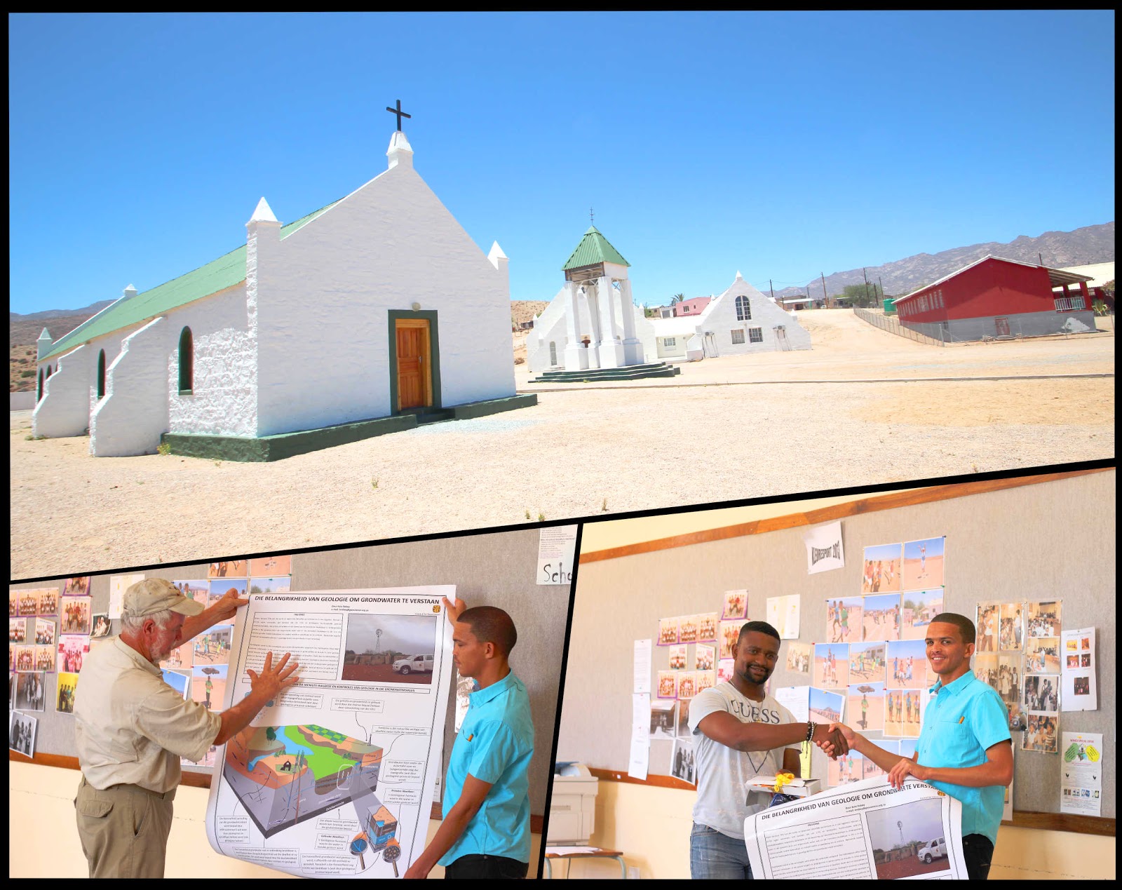
Top: View of Kuboes, Bottom: Nick explaining Kate's groundwater poster and Tshimane performing an official hand over of the poster and school supplies to Mr de Wet
As mentioned in
earlier posts, groundwater is essential to the survival of much of these
communities, however is rather poorly understood. Information on groundwater
stems from years of natural understanding, however with factors such as climate
change and the changing in the intensity of weather patterns, it would be highly
beneficial for these communities to be informed on these factors. This may
potentially aid in sustainability and avoid vulnerability of the largely
herding community. With this in mind,
one of our expert hydrogeologists, and fellow Richtersveld mapping geologist
class of 2009, Miss Kate Robey produced an immaculate poster highlighting
groundwater and its relationship with the surrounding geology. These posters
were really welcomed and received by a senior staff member, Mr de Wet. It is
envisioned that this simple gesture of information sharing may spark the hunt
toward understanding a changing climate and how we might have to evolve as
consequence to it. This also ended the Richtersveld Science Week! During this time
we managed to have a townhall meeting in Eksteenfontein, also meeting/workshop
with the local educators; school lecture in Kuboes and once more
meeting/workshop with the educators. We were also fortunate to create several
information posters and hand over some stationary and teaching aids. This is a
minor step toward something we hope could grow into a larger outreach
programme. Once more, if there are any suggestions, comments or if you would
like to be involved, please do not hesitate to contact us (tdhansay@geoscience.org.za).
Labels:
Groundwater,
Kuboes,
Richtersveld Science Week
Wednesday, November 26, 2014
2014 Diary: Day 17 - Tillites are not a girl's best friend
Today was the final mapping day of the Field School 2014!
Our participants were visibly upset and some even chose to stay out in the
field for longer than usual. A large team that included Taufeeq, Ngqondi, Sims,
Eve, Judy, Ndidi and Olma set out to answer some questions and recap the Gariep
Belt history. This team travelled the top of the basal thrust zone, exposed
within the Western region of the mapping area. This zone includes the tectonic
melange, recently mentioned and comprises of large (meter-thick) thrust faults
that have stacked diamictite and quartzite in a repetitive nature along at
least five noticeable thrust packages. Based on the steepness of these faults,
the team opted to spend some time practising their 4X4 skills before trying to quell
some lithostratigraphic issues.
4X4 training was done with the basal thrust packages as a
backdrop, literally. Participants engaged the low-range gear of our VW Amarok and attempted to crawl gently up the steep, rock slopes. All of this before having
to perform a three-point turn and crawl back down. This is vital skill needed
when driving in this kind of terrain and since we’re all alive now, everybody
passed this test with flying colours!
Slow and steady, keeps you alive! Low-range crawl down a slope
Now, problem number one: what is a diamictite; what is a
tillite:
A diamictite is essentially a sedimentary rock that has a
matrix (fine-medium grained) and at least two different kinds of clast. This is
as opposed to a conglomerate that mostly has one type of clast, commonly quartz
pebbles. Now, a tillite is a diamicitite (i.e. matrix with at least two
different kinds of clasts), but it has been deposited through glacial
processes. Moreover, how do we distinguish these two rock types in the field?!
Well, without the presence of proper drop stones (clasts that have “dropped”
into sediment and caused soft-sediment deformation) this is very difficult-
thus geology.com recommends diamictite as a safe name for “careful” geologists.
It will be interesting to see how our
team handles this based on what they've seen in the field and what the
literature elucidates to.
Spot the Diamicite/Tillite? Notice the dropstone!
Tomorrow further fears and questions will be quelled as we
slowly make our exit from the Richtersveld!
Labels:
Amarok,
Diamictite,
Tillite
2014 Diary: Day 17 - Diamictites are a girl's best friend
By: Nick, Tebogo, Penester and Khaya
Tebogo
showing that the diamictites can be your friend in certain circumstances!
Well only in the Richtersveld perhaps, and only on another
sun-drenched day, but after the singular (but expected!) non-success in earlier
diamond quests among Orange River gravels, team attention went beyond the
terraces to the rocks just above the basement of the last few days. The barren
landscape is often almost surreal with quartz-covered plains contrasting with
the dark desert varnish-covered outcrop ridges, though the geology today was
relatively consistent overall. Largely Kaigas diamictite, with variably-sized
clasts throughout, in this area the largest being carbonates along with various
granitoids. The fine-grained matrix is generally sheared, with spaced phyllitic
zones a feature, forming knife-edged outcrops protruding through the prevailing
scree. The contact zone with the basement granodiorites and conglomerates and
siltstones of the Vredefontein Formation is however marked by a gap in outcrop
rather than spectacular thrust.
Clockwise
from top left: the thorn among the roses; the contact between the basement
granodiorites in the left foreground and the metasediments of the Vredefontein
Formation; the zone proximal to the thrust though is marked by numerous quartz
veins; a drawback of removing your boots during lunch break is that they may
disappear!; you’re not looking for these boots are you?
Labels:
Diabase,
Diamictite,
Vredefontein
2014 Diary: Day 16 - Decollement
Our other team (Taufeeq, Olma, Khaya and Michelle) went out looking for big thrust faults,
specifically around the basal thrust zone of the Gariep Belt. After the
deposition of the Gariep Belt rocks (associated with the breakup of Rodinia ca.
750 Ma); this package was obducted onto the basement Vioolsdrift rocks during
the amalgamation of Gondwana. In order to better understand the scale of this
process, Olma, Khaya and Michelle (our esteemed guest from the office of the
COO) traversed across one of the major thrust faults in a zone of major faults
separating the Gariep from the basement. This was no easy feat, and highly
dangerous- we of course maintain the highest levels of safety and security (and
not just when we have guests from the office of the COO…).
The entire fault zone extends for several kilometres and
increases in topographically high peaks toward the top of the thrust succession.
This provides some idea of the thrust direction, kinematics and strain
partitioning throughout this sequence. Ductile deformation was present in the
diamicitite, with now rotated clasts illustrating thrust transport direction
along a top-to-the-west sense of motion. In addition, the quartzite of the
Stinkfontein suffered under the strain partitioning and displayed very high
levels of shearing and the formation of thin foliated layers. Finally, within
each thrusted block (bounded by metre-thick vein quartz brecciation), a
tectonic melange was present, where rocks buckled under the immense pressures.
Jumping for Joy: Olma and Khaya hunt for thrust tectonics. Bottom left: Olma showing one of the thrusts
With the temperature reaching above 40 degrees Celsius the
team did not attempt trying to get down the steep thrust. Did not try to get
down today, I should add. Tomorrow is a new day and likely to be a better day
to attempt this! This will unfortunately have to be done without Michelle, who
will return to Pretoria tomorrow. Michelle admitted that she enjoyed her visit
to the Field School: “I would love to come back…” she said. And she will always
be welcomed!
Until tomorrow- the final day of field mapping, here’s
hoping to go out with a Bang!
Labels:
decollement,
Gariep,
thrust
Tuesday, November 25, 2014
2014 Diary: Day 16 - The Low's Revisited
By Nick and his team (Penester, Haajiera and Ndidi)
Today saw the return to the previous area
in the north, partly necessitated by travelling for just over 3 hours to the
last outcrop of yesterday to recover Nick’s hammer…a small sacrifice in
comparison to the effort of procuring a new one! Plus a worthwhile exercise in
GPS navigation, so all was good. The day was once again spent in basement, but
this time with more variety in that extensive development of largely
intermediate to felsic volcaniclastic metasediments was encountered along with
the granodiorite. Dykes of the Gannakouriep suite are widespread, with dykes
intruding earlier bodies being a subject of interest. A quick escape down to
the Orange River (the juxtaposition of river and desert is a highlight of the
Richtersveld) to cool down was successful; the search for a possible diamond in
the river gravels was not!
Clockwise
from top left: ‘Hand of God’ eroded into the sheared basement metavolcanics;
team scale perspective; Gannagariep dyke-intruding-dyke exposure; Nick at the
granitoid contact with his re-claimed hammer, Haajirah getting her chance to
develop 4x4 skills in the real environment; Nick, Ndidi, Penester and Haajirah
escaping the 40+ deg desert heat today; Penester overcoming one of her field
‘fears’ (spot the little bird) :)
Labels:
Gannakouriep,
hand of God,
Procurement
2014 Diary: Day 16 - Neo-gee
By Neo and his team (Ngqondi, Tebogo and Shane)
Clockwise from the top: Ngqondi and Tebogo standing on a contact between the Tillite belonging to the Numees Formation Group and the Meta-Pelite of the Holgat Formation; Neo describing the intersection of a foliation plane perpendicular to bedding - possible fold axis in the phyllitic shales of the Holgat subgroup and An outcrop of metapelite rock interlayerd with shales and wackes beloning to the Holgat subgroup of the Port Noloth Group.
Labels:
Holgat,
metapelite
2014 Diary: Day 15 - And the Lows
From Nick and his Team
One of the other teams did the opposite; traversing the low
country in the north of the area. Michelle was visiting from Head Office and we
were out to impress: the search was for basement volcanic rocks, but these
proved rather to be rather enigmatic and sparse. Penester (Economic Geologist
mind you!) summed it up: ”I’ve seen enough granodiorites to last a lifetime”.
We couldn’t really disagree…
Clockwise
from top left; Basement Granodiorites of the Vioolsdrif Suite, locally highly
sheared but still the same unit; Shane and Penester capturing the details,
contemplating the more varied geology on the Namibian side of the Orange River,
“you can’t fool me, these are still sheared granodiorites!”
Labels:
De Hoop,
granodiorite
Monday, November 24, 2014
2014 Diary: Day 15 - Reaching New Heights
Today some our team members reached new heights, literally. Here
we follow Ngqondi, Haajiera and Ndidi as they summit some of the higher peaks
within the Richtersveld, all in the name of geology. The day started relatively
simple with a short section into what’s fast becoming quite the controversy,
namely the difference between a sheared tillite, or sheared diamictite. Tillite
being a diamictite (conglomeratic rock with at least bimodal clast type)
deposited by a glacier, and a dimictite deposited by any other means. A short
section to the west of the main gravel road outside the National Park gates
would show a simple stratigaphic change from diamicite/tillite to carbonaceous shales
and dolomite, likely being part of the upper Hilda Subgroup (Wallekraal into
Dabie River formations).
Some ptygmatic folding within the Phyllite units, and the team doesn't look to phased by the altitude
Later in the day, this team then began a section through,
what they would later discover, a tectonic melange. This section involved
climbing some 500 m through a thrust stacked sequence of phyllite, dolomite and
siliclastic sediments. Several sequences were found to be repeated due to
repetitive thrusting. These thrusts were clearly marked with the presence of
thick brecciated vein quartz and an increase in the foliation. The dramatic
topography was also discovered to be as consequence to the immense thrusting in
this region with the upper peaks thrust-bounded with breccia. Lower diamicitite
and phyllite had undergone ductile shearing and developed clear shear sense
indicators. These all illustrated a top-to-the-west sense of shear, maintaining
consistency with the regional shearing direction. This was a structure-heavy
section and will really test the team’s abilities of interpreting the field
relations and illustrating it on their geological maps.
High, but Haajiera getting even higher!
After the hike the team felt good. Ndidi was asked about her
experience and said: “Haai, no this was too much…”. Rest will be well deserved
this evening, and they’ll need it before tomorrow!
Labels:
Carbonate,
Phyllite,
Tectonic Melange
2014 Diary: Day 14 - The Sea That Took the Old Man Away
Every now and then the field school has one day off; and
that was today as the team travelled to Port Nolloth to do some shopping and
spend some time at the beach. The shopping was however, unsuccessful as we were
chased away from the local Spar. Having arrived just on closure time (Spar in
Port Nolloth closes at 12h00 on Sunday’s) the team was unfortunately turned
away by the manager: “NO WAYS…” he roared as the team begged to buy food (meat
and vegetables). “Safety Reasons” we were told. I suppose that must mean that
we’re looking a bit rough after a few days in the field; and that must mean
that we’re doing something right?! In any case, the team was quite disappointed
in the way we were treated and had to leave empty handed; and empty stomached.
Port Nolloth has long been known as the gateway to the
Richtersveld. From Port Nolloth the road north passes through Alexander Bay and
the Orange River mouth (a long way from the Gariep Dam). This is of course of
special interest with regard to alluvial diamonds that have travelled across
South Africa along the Orange River. Following Alex Bay, the road enters one of
the most scenic parts of South Africa, the desert setting around Groot Derm and
into southern Richtersveld. Originally, Port Nolloth was the major exporting
point for copper (from the Okiep District) and diamonds (Orange River mouth).
After the Spar incident, moods were lightened with Tebogo’s
second ever visit to the beach! And, this time she was duly dumped into the
ocean (All in good fun). Sand castles were built, ball games played and plenty
of time given for sun bathing. Dark clouds quickly loomed, and must mean that
it’s time to get back to the field…
Field School looks like way too much fun
Labels:
Alexander Bay,
Port Nolloth,
Spar
Location:
Port Nolloth, South Africa
Sunday, November 23, 2014
2014 Diary: Day 13 - Gannakouriep in 60 seconds
As we near the end of the first week of field work, it's becoming very clear that our teams are very well set in their mapping. The rock descriptions and structural measurements are of the highest quality and we'll be expecting great results at the end of this year's field school. Of course, slight complications do arise in the field. Today, we follow Penester, Shane and Eveline. This team traveled deep into the Richtersveld in an attempt to complete one of the more isolated sheets. This journey was long and arduous, and could have easily warranted a fly camp. In the end, the planned traverse was not possible, due to current soil rehabilitation programme in an exceptionally long drive.
Team putting the Amarok to the extremes of its capabilities
Subsequently, this team did some regional mapping. Firstly, looking at some of the Gannakouriep dykes and later extrusive felsic volcanic rocks. The Gannakouriep dykes were emplaced during the early stages of the Gariep Orogeny, ca. 717 Ma; and represents the maximum age of this orogenic event. In addition, these dykes show evidence of deformation in places, related to syntectonic emplacement; and displays a very strong foliation. In places, the Gannakouriep could be seen near bright felsic volcanics, together these bounded within the Vioolsdrift basement gneisses.
Despite the lack of intense geology, the team did manage to test a VW Amarok along some of the moderately challenging tracks within the Richtersveld National Park. With a low ground clearance (approximately 205 mm - with 265/70/16R BF Goodrich AT) and a 2.0 liter Bi-turbo engine, producing only 132 KW of torque (enough the carry passengers and rock samples), the Amarok does not necessarily convince relative to bigger Toyota's. However, it managed surprisingly well (just needing to be taken very slowly over the tricky sections, to avoid scratching the undercarriage). Dragging the towbar could not be avoided though - the approach angle is simply not sufficient (due to the bling-bling nudge bar). Off-roading gadgets are plentiful: hill assist, electronic differential lock and anti-slip regulation, all of which goes a long way to making the drive as comfortable as possible.
Geology-wise, note that there are lots of steeply foliated carbonates and quartz-rich shears along most of these roads. These develop razor sharp edges that will slice through the relatively soft rubber compound of the BFG's. It's worth noting that this particular Amarok had BFG tyres fitted 3 months ago and are now horribly gutted and pitted. Luckily, the team hikes most of the time and are well prepared for any potential quagmire-situation.
Final assessment: 6/10.... Until you get stuck, of course.
Labels:
Amarok,
Gannakouriep,
Richtersveld
Subscribe to:
Posts (Atom)